

 In March-May 2021 The National Trust (NT) published a ‘game changing’ map illustrating the threat climate change poses to some of its most iconic and culturally significant sites – and offered some solutions on how to tackle it.
The National Trust writes:
…This map will ensure trees are planted in the places and where they are most needed…
The National Trust writes:
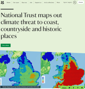
It is the first map of its kind that plots data in this way and will help the charity identify the hazard level facing its countryside locations, monuments, coastlines and historical sites in England, Wales and Northern Ireland.
By plotting its places alongside existing data on climate change related events, the charity is able to understand how, at a local scale, potential risk factors (extreme heat and humidity, flooding, landslides, coastal erosion, soil heave and high winds) could change by 2060.
Working to a worst-case model of no intervention on emissions, the map is intended to be used as a “flagging tool” to highlight potential hazards to the locality of a site.
By identifying areas at risk, the charity can pinpoint locations that may need interventions like tree planting to slow water run-off, peat bog restoration to hold back water, river restoration or areas that need more shade due to extreme heat.
The data will be used by the charity to look at risks to the landscape, with landowners working together to engage local communities to volunteer in their area and help in the fight.
The National Trust is already taking measures to try and tackle the threat posed by climate change by planting or establishing 20 million trees – an area the size of Birmingham – and becoming carbon net zero by 2030.
This map will ensure trees are planted in the places and where they are most needed, with 50,000 having been planted in the last 12 months including in north Devon, Lancashire, north Wales and Dorset.
The next phase of the project will build on work already undertaken to identify and act in areas in which homes for wildlife are at risk and where species reintroduction like beavers may help the environment.
It could also see government bodies from England, Wales, Northern Ireland and Scotland plot the heritage locations they care for to illustrate the threat to the whole UK historic environment.
Coastal areas at risk of collapse or sand dune movements due to rising sea levels will also be highlighted in the future, which will also enable more informed solutions.
Water or heat adaptive building materials will be used in areas shown as high risk from flooding or rising temperatures and humidity, or even inform where to build if an area is prone to soil heave.
The charity’s historic buildings and collections can be better protected from extreme weather conditions and resultant increase in pests and damage arising from humidity and water.
The release of the map comes eight months before world leaders gather in Glasgow for COP26 to formulate a global plan on how to tackle the climate crisis at a global level.
But the Trust is already working in partnership with government bodies to plot all cultural heritage sites in the UK. The next phase of the map will further refine the methodology to really tackle the impact of the crisis at home.
The map is drawn using a “worst case scenario” in which gas emissions continue their current trajectory unchecked with 5km hexgrids plotting the threat level from one to five.
Areas shaded red represent the highest exposure level, meaning climate change-driven weather events may pose a significant threat to that area.
Assuming there was no intervention on emissions before 2060, key findings include:
• The number of National Trust sites at high or medium risk of climate related hazards could increase from 20,457 (30 per cent) in 2020 to 47,888 (71 per cent) in 2060 out of a total 67,426 sites.
• The number of National Trust sites in the highest threat level area could rise from 3,371 (five per cent) to 11,462 (17 per cent) in the same period.
• The number of National Trust scheduled monuments at high or medium threat risk are projected to increase from 1453 (27 per cent) today to 3861 (72 per cent) out of a total 5388 by 2060.
• Heat and humidity will rise dramatically, with the south east particularly susceptible to drastic increases. A third of National Trust sites in the region will experience at least 15 days of over 30 degrees a year. This will be exacerbated in urban areas like London, due to the Urban Heat Island effect.
• Storm damage, landslides and flooding we have experienced in recent years are set to become common occurrences and more widespread, particularly in Wales and the North of England
• Coastal erosion and flooding will increase in Northern Ireland, potentially leading to more landslides around locations like the world-famous Giants Causeway.
National Trust Director for Land and Nature Harry Bowell said: “This map is a game changer in how we face the threat climate change poses to the places we care for.
“While the data draws on a worst-case scenario, the map paints a stark picture of what we have to prepare for.
“But by acting now, and working with nature, we can adapt to many of these risks.
“One of the most exciting opportunities here is the map ensures a joined-up approach in which neighbours, landowners, charities and developers can come together to identify risks and collectively intervene to tackle issues and make large scale change.
“Planting trees, restoring peatlands, slowing the flow of water in flood prone river valleys and preparing our places and collections – as well as staff and volunteers – for the increased heat and humidity are some of the measures this map can inform.
“And government can play its part by strengthening its environment bill investing in green infrastructure, growing the sectors, jobs and industries that will enable us to tackle and adapt to the impacts of climate change before world leaders come together at COP26 in November.”
A spokesperson for the independent Climate Change Committee said: “This map will support our research and analysis into the vulnerability and exposure of some of the nation’s most important and sensitive heritage sites to future climate change.
“The pioneering approach could be used to inform our thematic reports and has the potential to shape the future of how we need to adapt to avoid some of the worst impacts of climate change at a local granular level.”
Duncan Wilson, Chief Executive of Historic England said: “Climate change is putting our historic places under threat. Warmer, wetter winters and hotter, drier summers mean hazards such as flooding, intense rain, drought and overheating will become more frequent. We welcome this work by 3Keel and the National Trust and are excited to be working with them and our colleagues around the UK to develop this approach further, so that we can understand the hazards faced by all our heritage.
“Understanding these is the first step towards adapting to these challenges, which will allow us to continue to conserve our heritage for future generations.”
Dr Kate Roberts, Cadw’s Head of Historic Environment said: “The impact of climate change, and in particular the extreme weather events that we are experiencing with increasing frequency, are one of the most significant threats facing our historic environment.
“Our actions today determine the historic environment that future generations will experience. Knowing how and where to focus our resources is challenging which is why research such as this is so critical.”
A spokesperson for the Department for Communities in Northern Ireland said: “We are delighted to be working together with the National Trust , HES, HE and Cadw to share our expertise and work towards a better understanding of the impacts of climate change on our historic places and landscapes.”
Case studies:
Heat and humidity at Ham House
The rapid increase in heat and humidity experienced here means that 40C days could become common by 2040, which means the head gardener now “applies a climate change perspective to every single action in the garden”. That means altering the types of plants introduced to include those more resilient to high temperatures like cannas and agaves. And a Mediterranean grown diet of outdoor grown aubergines, chillies and a long tomato season could become the norm.
As summer temperatures increase, shade will need to be provided from trees in open hours and garden working hours have already shifted to start and finish earlier to avoid the afternoon summer heat.
Flooding at Lyme Park
Regular long dry spells followed by heavy downpours has led to increased flooding around Lyme Park, Cheshire, with flooded gardens and water pouring into the property.
A major flood in July 2019 caused significant damage, as the lake overflowed and spread over 25 tonnes of debris across the garden.
Fast flowing waters has also caused dry stone walls to collapse and saturated paths become unnavigable muddy bogs.
The team is intervening with tree planting on moorlands to hold back the flow of water and reduce flooding risks, as well managing water leaving the estate to prevent other areas flooding.
Landslides and coastal erosion
There are regular landslides on the coastline around the world-famous Giants Causeway as a result of increased rainfall. Eighty miles away on the east coast of Northern Ireland, Mount Stewart has worked hard over the last decade to tackle the effects of coastal erosion partly due to rising sea levels around the shores of Strangford Lough. To mitigate this, the car park has been relocated to more sheltered ground and the area has been re-purposed by using fauna to act as a dense shelterbelt from the incoming sea water.
In 2014, the chalk cliffs at Birling Gap suffered seven years’ worth of erosion in just two months, in part due to heavy storms. The rate of erosion, although naturally occurring due to the geology of the area, will only increase as we see more storms, rainfall and higher sea levels.
Often seen as a microcosm of the UK, Brownsea Island has also suffered extensive coastal erosion in recent years due to increased frequency of storms and high tides. We’re looking at options for the future including ‘modular steps’ – movable lengths of metal stairs designed to be fixed quickly and safely into slopes of varying angles, so that they can shift as the coast shifts.
Soil shrink heave in the Yorkshire Dales
An otherwise sound 18th century barn collapsed at Malham Tarn, Yorkshire Dales as a result of soil shrinkage. The building was built with no foundations and as soil moved the back wall shifted slightly and the roof collapsed in on itself. Prior to this it had not been classed as being in a poor state of repair. Thin limestone soils are very vulnerable to drought and erosion. To prevent possible damage, teams can now intervene with natural solutions like tree planting and certain flora to manage the water table and absorption beneath the soil. If flagged as a hazard early enough, others may be able to shore up foundations or intervene with natural solutions.
Storm damage in Wales
Storms are expected to cause issues for falling trees in the future, especially as extreme weather leaves them weakened and more susceptible to disease like ash dieback, with falling branches causing a hazard for visitors.
The C16th listed farmhouse of Dyffryn Mymbyr in Snowdonia has mitigated against the impact of increased driving heavy rainfall by installing “slate hanging” on the exposed end of the building to protect it. Made famous by the “I bought a mountain” book by Thomas Firbank, the historic building will now be protected from future increased heavy rainfall. This is just one example of how to lessen the impact of increased rainfall which thousands of National Trust properties are exposed to, as highlighted in the hazard map.
Pest and disease
The changing climate has an impact on plants across the country. Up to 75 per cent of heather has been lost on the hills at Long Mynd in Shropshire and Holnicote in Somerset due to a combination of summer drought and damage from the heather beetle, which is able to thrive due to warmer winters. The trust also faces a £2m bill to fell trees that pose a risk to the public due to ash dieback. An estimate 40,000 trees will need to be removed this year compared to 4,000 in a normal year. Extreme weather places trees under increased stress leaving them more susceptible to disease like ash dieback.

Why is IHBC@COP26? Because ‘Conserving our Places Conserves our Planet’
Join IHBC’s globally accessible virtual built and historic environment ‘Conservation Helpdesk+’, #IHBCHelpdesk #CultureCOP26 – open 31/10 to 12/11)
Listen the IHBC@COP26 ‘Climate and Conservation’ Podcasts anytime, or from the ‘Conservation Helpdesk+’